| Line 278: | Line 278: | ||
===Kauai Island - including Lihue(HLI)=== |
===Kauai Island - including Lihue(HLI)=== |
||
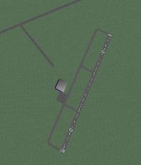
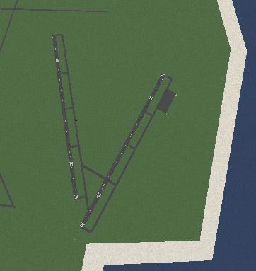
| + | <u>Lihue (HLI):</u>[[File:Lihue_n_10k.jpg|frame|Lihue, north, 10k]] |
||
| − | Lihue (HLI): |
||
*The main airport to the west of honolulu |
*The main airport to the west of honolulu |
||
*Rwy 3/21, ILS rwy 21 only |
*Rwy 3/21, ILS rwy 21 only |
||
*Rwy 17/35, ILS rwy 35 only |
*Rwy 17/35, ILS rwy 35 only |
||
| + | |||
| − | <u>Port Allen:</u> |
||
| + | |||
| + | |||
| + | |||
| + | |||
| + | |||
| + | |||
| + | |||
| + | |||
| + | |||
| + | |||
| + | |||
| + | |||
| + | |||
| + | |||
| + | |||
| + | |||
| + | |||
| + | |||
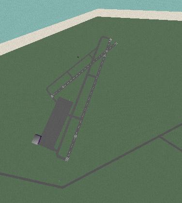
| + | <u>Port Allen:</u>[[File:Port_allen_n_10k.jpg|frame|Port Allen, north, 10k]] |
||
*tiny airstrip, with adjacent tarmac (no taxiway) |
*tiny airstrip, with adjacent tarmac (no taxiway) |
||
| Line 291: | Line 310: | ||
*From Lihue, fly or follow VOR outbound 255, 15 miles |
*From Lihue, fly or follow VOR outbound 255, 15 miles |
||
| + | |||
| − | <u>Princeville:</u> |
||
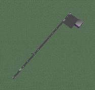
| + | <u>Princeville:</u>[[File:Princeville_n_10k.jpg|frame|Princeville, north, 10k]] |
||
*tiny airstrip with adjacent tarmac (no taxiway) |
*tiny airstrip with adjacent tarmac (no taxiway) |
||
| Line 299: | Line 319: | ||
*Apron at rwy 23 end, max capacity one small aircraft |
*Apron at rwy 23 end, max capacity one small aircraft |
||
*from Lihue, fly or follow VOR outbound 335 16 miles |
*from Lihue, fly or follow VOR outbound 335 16 miles |
||
| + | |||
| + | |||
| + | |||
'''NOTE:''' Niihau has no airport! just hangars and a bldg... |
'''NOTE:''' Niihau has no airport! just hangars and a bldg... |
||
Revision as of 11:09, 6 February 2012
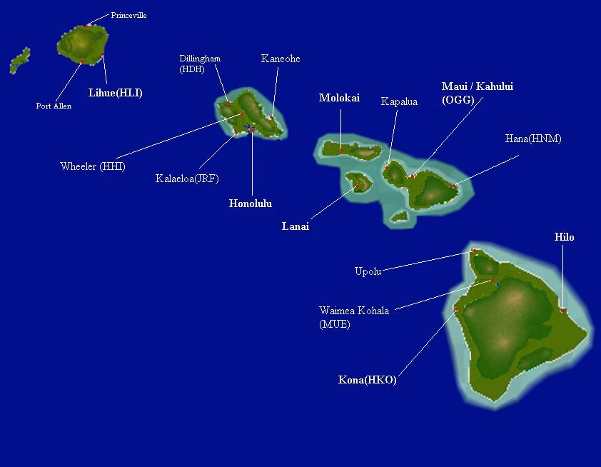
Hawaii
Having the greatest number of destinations of any default map in YSFlight, this map is a favorite for Virtual Airlines(VA), who are looking to establish their own network of routes.
Labelled map of Hawaii. Int'l airports in bold. Small airports have a smaller font.
It also has the greatest distances to travel between airports, giving more realism for pilots of large airliners.
There are differences with online and offline play. Cheifly, there are servers with hostile objects which weren't included in the original map. There can also be servers running endurance mode, where non-player aircraft attack players' aircraft. As there is a general rule in YSF servers not to shoot other players without consent, the hostiles are perfect for military pilots looking to hone their skills. In online play, civilian pilots will want to avoid certain routes, or learn to divert safely around the hostile areas on their way.
Also, there have been cases of duplicate NAV entries for all airports in Hawaii. In these servers, it appears that two versions of the Hawaii map had been loaded by mistake, and all that remains are coordinates for the duplicate airports. Also, ILS names are not always the same, especially in Hawaii, where they have names like "carrier" and "homebase" The original names included the airport name and runway number (such as "HNL_08L", which is useful in finding out the runway direction at unfamiliar airports, and essential for verifying you are using the correct ILS when in poor visibility conditions.
Oahu Island - including Honolulu(HNL)
Honolulu(HNL)

Honolulu airport, north, 10k
- Rwy 08L/26R, ILS 08L only
- Rwy 08R/26L, ILS 08R only
- Rwy 04L/22R
- Rwy 04R/22L
- No fuel supply
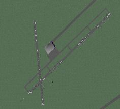
Kalaeloa(JRF)
Kalaeloa, north, 10k
- Rwy 04L/22R Short!
- Rwy 04R/22L, ILS 04R only (may be named "04R" or blank - or both at the same time, your pick)
- Rwy 11/29
- Next to Honolulu, to the west
Kaneohe a.k.a. MCBH

Kaneohe, north, 10k
- Desert patch by the sea, north of Honolulu
- Rwy 04/22, ILS on rwy22
- Terrain on approach to 04, maybe thats why no ILS.
- No apron, just a full-length taxiway
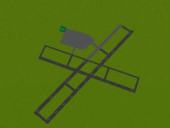
Wheeler Airfield(HHI)

wheeler, north, 10k
- Located in central area NW of Honolulu
- Rwy 6/24
- Online play: doesn't always have a VOR, sometimes it has an NDB.
Dillingham(HDH)
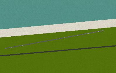
dilingham, north, 10k
- super-slim airstrip NE region of island.
- Rwy 08/26
- Surprisingly, it is long enough for a B737 to take off, yet doesn't even have an apron.
- Warning: one version of Hawaii places Dillingham NDB in position #9(supposed to be reserved for 'next page' function) if you see it at this slot, DO NOT PRESS 9 - it will crash YSFlight!!
NOTE: Koko head: is not an airport
Molokai Island
Molokai
molokai, north, 10k
- Rwy 5/23, longer, too short for large aircraft (A340 fail takeoff), tight for medium airliners (b737 on takeoff)
- Rwy 17/35, shorter
- terrain 7000t in area of airport
- Online play: sometimes erroneously called Kalupapa in NAV menu
- [PMNV only]the map shows a location of molokai SW of kalupapa.
Lanai Island
Lanai:
lanai, north, 10k
- Rwy 03/21, ILS rwy 03 only, too short for large airliners (A340 fail takeoff), tight for medium airliners (b737 on takeoff)
- 4000ft terrain obstructing approach rwy 21
- Apron on rwy 03 end, max capacity 1 medium airliner
- (only sometimes - modified map?) no taxiways, backtracking is necessary
- fuel available
- From HNL, Fly or follow VOR 120 degrees out 62 miles
Maui Island
Maui aka Kahului aka OGG:
maui, north, 10k
- Rwy 02/20, ILS both ends (names can both be blank)
- Rwy 05/23, shorter runway, tight for medium airliners (B737 on takeoff)
- fuel available
Hana(HNM)

Hana, north, 10k
- Rwy 26/08
- bearing 010 from Maui
Kapalua aka JHM

kapalua, north, 10k
- Rwy 7/25
- bearing 290 from Maui, 17 miles
- VOR name is JHM
Hawaii Island - incl Kona(HKO)
Kona(HKO):
kona, north, 10k
- Rwy 17/35 ILS both ends
- Terrain 9000ft to east
- From Honolulu, fly or follow VOR 130 outbound for 145miles
- From Lihue, fly or follow VOR outbond 125 for 230 miles.
Hilo:

Hilo, north, 10k
- Rwy 8/26, longer, ILS on 26 only, with a blank name
- Rwy 3/21, shorter, ILS on 21 only, named "island base", tight for medium airliners (B737 on takeoff)
- Terrain 14000-17000ft in area
- From honolulu, fly or follow VOR 120 for 189 miles
- From Lihue, fly or follow VOR outbound 120 for 278 miles.
- ILS names at the field may differ; they were altered
Waimea Kohala(MUE)
Waimea Kohala, north, 10k
- Rwy 22/4
- has a VOR, not for large a/c but can land planes such as YS-11
- From Kona, Fly or follow VOR 050 outbound (if MUE isn't in the NAV-1 list)
Upolu
Upolu, north, 10k
- Rwy 7/25
- Has a VOR - but when online, sometimes not...
- From kona, fly or follow 020 outbound radial, 34 miles
[PMNV]Bradshaw: From Kona, fly or follow kona VOR outbound 060
NOTE: False VORs near Kona!: Upolupoint; Kamuela(2 hangars and approach lights in water?); Bradshaw(just a mountain in stock map); OGG(not an airport, leads to maui)
Kauai Island - including Lihue(HLI)
Lihue (HLI):
Lihue, north, 10k
- The main airport to the west of honolulu
- Rwy 3/21, ILS rwy 21 only
- Rwy 17/35, ILS rwy 35 only
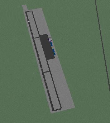
Port Allen:
Port Allen, north, 10k
- tiny airstrip, with adjacent tarmac (no taxiway)
- Rwy 9/27
- Runway too short for medium airliners; tight for regional aircraft(DC-9-16 on landing), recommended for small aircraft only.
- Apron at rwy 27 end, max capacity one small aircraft
- From Lihue, fly or follow VOR outbound 255, 15 miles
Princeville:

Princeville, north, 10k
- tiny airstrip with adjacent tarmac (no taxiway)
- Rwy 5/23
- Runway too short for medium airliners; tight for regional aircraft, recommended for small aircraft only.
- Apron at rwy 23 end, max capacity one small aircraft
- from Lihue, fly or follow VOR outbound 335 16 miles
NOTE: Niihau has no airport! just hangars and a bldg...
[PMNV]Barking sands: west side of Lihue island, bearing 270 from Lihue